Google have done an impressive job of 3D modelling the venues for the Football World Cup 2010 in their Google Earth application. Along with the stadiums, one can also get a good idea of the geography of the surrounding cities and scenery. The following video exhibits this:
Showing posts with label places. Show all posts
Showing posts with label places. Show all posts
Jun 9, 2010


Jan 7, 2010
Sherlock Holmes for the 21st century

I went to the cinema to expecting to see a different Sherlock Holmes, a character repackaged to cater to a new market, in a crude manner that detracts from his original essence. Didn't happen.
The new Sherlock Holmes, played by Robert Downey Jr., is a much more dynamic character - younger, more adventurous, bit less of the English gentleman than previously depicted. Nevertheless, the core of the character hasn't been lost - the eccentricity, self-assuredness, intense concentration, and even human weaknesses. Jude Law would not have been my choice for Dr. Watson, but he's pulled it off quite well, next to Downey's Holmes. So, if you are a fan of the classic A.C.Doyle's Sherlock Holmes, you probably won't be disappointed.
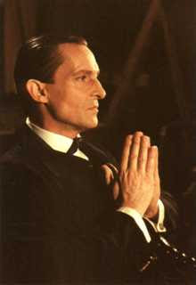 The marked difference was in the the look of Holmes. The new movie has not shied away from redefining the portrait - gone is the combed back hairstyle, the sharp jawline and chin. Downey doesn't look anything like the classic Holmes, who has been played best by actor Jeremy Brett (see on the right) in the almost complete series by Granada Television. Jeremy Brett was probably the first to capture the full theatrical intensity of the character, watching him was like following the original sketch in the books. In fact, my friend Prasanna aptly remarked that the villain in the movie is a closer look to the classic Holmes. Not commonly known is the story that the look of Holmes didn't come from the author A.C. Doyle but from his first illustrator.
The story of Sherlock Holmes first began in 1887, with the story A Study in Scarlet, published in Strand magazine, London. The Sign of Four was published in 1890, and the series The Adventure of Sherlock Holmes began in 1891 ...
With the stories serialized in The Strand came the first illustrations, and it was Sydney Paget who was to fix the the features of the tall, thin, bony character for generations of enthralled readers. The story is that Sydney was actually commissioned by mistake, instead of his brother Walter, whose work the magazine knew through his illustrations for Rider Haggard and Robert Louis Stevenson. If so, this quirk of fate was balanced by a kind of poetic justice on Sydney's part, for he used his brother's lean features as his model for Holmes. And later after Sydney's death in January 1908, Walter himself illustrated one of the stories, The Adventure of the Dying Detective. What Holmes would have looked like had Walter got there first we can only guess, for, like all the other artists commissioned to continue Sydney Paget's work, Walter did not stray far from the image of himself Sydney had fleshed upon the bones of Conan Doyle's creation.
- Preface, The Complete Illustrated Sherlock Holmes


Holmes has been seen that way ever since. There have been many actors in to play the detective, all bearing resemblance to Sydney Paget's illustration.
However, more than that, the reason Sherlock Holmes has avid followers around the world and across generations is his personality. In a sense he is very much a 20th century man, before his times, even bit of a rebel. His firm foundation in scientific principles led him to be accessible, yet his public performance of a mind-reader and magician is highly entertaining. He's a magician who, in the end, reveals his tricks of the trade, leading all who read the accounts to think that they can follow the indicated lead. He's a fictional character that has inspired creation of countless other similar fictional characters. It becomes more than just a story.
The new movie with all the benefits of modern technology (and big budget) fills in the larger picture as well. The musical score suits the setting. There are panoramic views of the London of the late 19th century, with references to the social, technological and industrial upheavels taking place ..
Arthur Conan Doyle's birth year, 1859, fell 22 years into Queen Victoria's 64-year reign, a time of unparalleled growth and optimism for the British Empire. Resources and labor taken from colonies worldwide had made England prosper, and the time of serious independence struggles lay in the distant future. Business flourished, technology blossomed, and London grew at a great rate - from one million people to six in the space of a century - creating problems of urban overcrowding familiar to us today: poverty, homelessness, drug abuse, crime. While the great divide between rich and poor and the economic and human strain of maintaining the colonies exacerbated social problems that were as yet insoluble, Victorian Britons, led by Victoria's husband Albert, put their faith in technology and science. The contrasts and conundrums of this fascinating time provided Conan Doyle with the raw material and the backdrop for Sherlock Holmes: a man of science, undistracted by the gentler passions, who moved easily through the disquieting urban space, using his wits to solve its moral and practical dilemmas.
- Sherlock Holmes, Victorian Gentleman http://sherlockholmes.stanford.edu/history.html
Come to think of it, there are actually many parallels to the enormous changes taking place in cities of the today's emerging nations. Many of similar patterns and contrasts can be spotted in places such as New Delhi. It could be a new setting for a modern fictional detective.
Jan 6, 2010
Tallest building on Earth
The latest tallest building on Earth, Burj Khalifa (formerly Burj Dubai), was inaugurated in Dubai in a glittering ceremony of fireworks, lights, and musical fountains. The building touches the milestone of 828 meters (or 2,717 feet) with 162 floors. Construction started on 21 September 2004, and has been completed on 4 January 2010. The opening ceremony can be seen here
A comparison with some of the existing tallest man-made structures (not counting projects in planning or construction) produces the diagram below. If you want to consider New Zealand's tallest structure, the Auckland Sky Tower at 328 meters, you can put it at approximately the size of the Eiffel Tower on the diagram. India's highest buliding is currently the Imperial towers in Mumbai at 60 floors and 249 meters.

Having the good fortune to have seen almost all the structures in the diagram(except for the Taipei 101 & CN tower), I look forward to seeing this one.
Here's another detailed diagram comparing world edifices reaching above 400 meters benchmark. The current completed buildings are in full representation, while the in-progress constructions are shown as line drawings.

It's probably unlikely that the Burj Khalifa will remain the highest building with so many newly emerging nations and conglomerates also eyeing that coveted title. Burj's predecessor the Taipei 101 (509 meters) only held the title for 6 years, not allowing the Shanghai World Financial Centre (492 meters) to even get a chance. Previous to that the Petronas Towers, Kuala Lumpur (452 meters) were the highest for 6 years, and the Willis Towers, Chicago (formerly Sears Towers) was the highest for 24 years.
However, it will be difficult to match the longevity of the building that held the title for 3880 years - the Great Pyramid of Khufu (Cheops). Here is an interesting, though very detailed diagram of the tallest buildings of the 'old' world.

A comparison with some of the existing tallest man-made structures (not counting projects in planning or construction) produces the diagram below. If you want to consider New Zealand's tallest structure, the Auckland Sky Tower at 328 meters, you can put it at approximately the size of the Eiffel Tower on the diagram. India's highest buliding is currently the Imperial towers in Mumbai at 60 floors and 249 meters.

Having the good fortune to have seen almost all the structures in the diagram(except for the Taipei 101 & CN tower), I look forward to seeing this one.
Here's another detailed diagram comparing world edifices reaching above 400 meters benchmark. The current completed buildings are in full representation, while the in-progress constructions are shown as line drawings.
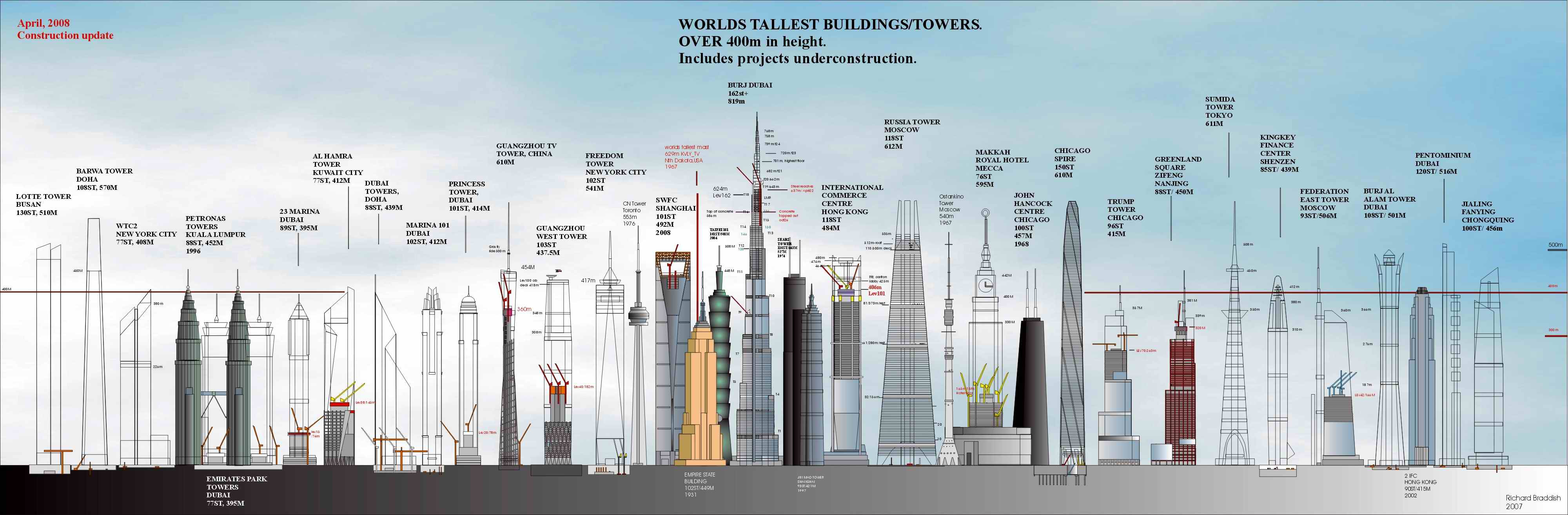
It's probably unlikely that the Burj Khalifa will remain the highest building with so many newly emerging nations and conglomerates also eyeing that coveted title. Burj's predecessor the Taipei 101 (509 meters) only held the title for 6 years, not allowing the Shanghai World Financial Centre (492 meters) to even get a chance. Previous to that the Petronas Towers, Kuala Lumpur (452 meters) were the highest for 6 years, and the Willis Towers, Chicago (formerly Sears Towers) was the highest for 24 years.
However, it will be difficult to match the longevity of the building that held the title for 3880 years - the Great Pyramid of Khufu (Cheops). Here is an interesting, though very detailed diagram of the tallest buildings of the 'old' world.

Image credits: Wikipedia.org & flickr.com
Dec 22, 2008
Library of the Human Imagination
Here's a personal library that most of us can only dream of. In fact, most public libraries can also just aspire to.

 Stuffed with landmark tomes and eye-grabbing historical objects—on the walls, on tables, standing on the floor—the room occupies about 3,600 square feet on three mazelike levels. Is that a Sputnik? (Yes.) Hey, those books appear to be bound in rubies. (They are.) That edition of Chaucer ... is it a Kelmscott? (Natch.) Gee, that chandelier looks like the one in the James Bond flick Die Another Day. (Because it is.) No matter where you turn in this ziggurat, another treasure beckons you
 - Wired News Article (includes more photos)
Here's a fascinating video talk by the owner/curator, Jay Walker:
 Stuffed with landmark tomes and eye-grabbing historical objects—on the walls, on tables, standing on the floor—the room occupies about 3,600 square feet on three mazelike levels. Is that a Sputnik? (Yes.) Hey, those books appear to be bound in rubies. (They are.) That edition of Chaucer ... is it a Kelmscott? (Natch.) Gee, that chandelier looks like the one in the James Bond flick Die Another Day. (Because it is.) No matter where you turn in this ziggurat, another treasure beckons you
Here's a fascinating video talk by the owner/curator, Jay Walker:
Aug 10, 2007
Unrehearsed Nature - Battle at Kruger
Have cameras everywhere, one is bound to capture something absolutely fantastic. As in this case - a tourist on a safari captures a priceless moment, now called the Battle at Kruger. The video has already been seen 9.38 million times as I write this.
It shows lions capture a water buffalo calf, then crocodiles go after the lion's catch. A tug-of-war ensues. Meanwhile the buffalos regroup and come back to the rescue! Surely not the regular Animal Planet stuff, there's no human daring to interfere in this drama.
It shows lions capture a water buffalo calf, then crocodiles go after the lion's catch. A tug-of-war ensues. Meanwhile the buffalos regroup and come back to the rescue! Surely not the regular Animal Planet stuff, there's no human daring to interfere in this drama.
Aug 9, 2007
दुनिया की सबसे ऊंची सीमा पे संगीत की धारा

हिंदी में मेरी पहली ब्लोग। ब्लॉगर में अंग्रेजी के अलावा पहली भाषा हिंदी डाली गयी है।
बीबीसी से खबर है के एक संगीत ग्रुप ने एवरेस्ट (या सागरमथा) के करीब बुलंदी पे कांसर्ट पेश किया। पता नही अगर इतनी कम आक्सीजन वाली हवा में जाके इन कलाकारो की धुन भी ना बदल गयी हो।
ये वर्ल्ड रेकॉर्ड तोड़ने और चन्दा इकठ्ठा करने के लिए किया गया। आगे की खबर इस साइट पे है।
.
Jul 31, 2007
National Library 3D Building Model for Google Earth
I'm submitting this model to Google Earth today.
Google Sketchup Model

Link to this image: http://farm2.static.flickr.com/1176/962260016_9c348e09e3_o.jpg
Google Earth view

(Click on Image to Enlarge)
Link to this image: http://farm2.static.flickr.com/1010/971357387_6f747e9bc0.jpg
Link to large image: http://farm2.static.flickr.com/1010/971357387_fb76db9f49_o.jpg
Background
Google Earth is a very popular downloadable program for users, that allows one to 'dive in' and navigate the earth as seen from the air. Originally, this would have started out at as a GIS (Geographical Information System) that was mapping satellite photos on to the globe, but a rapid pace of innovation has introduced a lot of extra possibilites. Basically, if you can place it on a map, then it should be placed on this application. A very popular such feature layer is 3D buildings where if you navigate to any place on Google Earth, you can actually see 3D realistic models of buildings standing in their positions. The first such models were built by Google, but since has been opened up to accept user built contributions. Google released a very user-friendly application called Google Sketchup to build such models, and an online repository called 3D Warehouse to store the contributions. Google then assesses these for their suitability for inclusion.
Video of the Model
Current status (and how to see it in Google Earth)
Right now this model has been submitted to Google's 3D warehouse. You can search for it by going to the 3D Warehouse site and searching for "National Library" or more specifically "National Library of New Zealand". If you are using Google Earth, please note that the model will not turn up by default in Google's 3D building layer until it goes through Google's approval process, but you can still see it by following the instructions here to get the Google 3D warehouse network link.
I've been doing this project in my 'spare time' at home. Now that I've finished, my wife will finally be happy to get more of my time. Not easy being married to a techie sometimes.
Also ..
just in time for the Library building's 20th Anniversary of completion (5 August 2007)!

Relevant Links
Google Sketchup Model
Link to this image: http://farm2.static.flickr.com/1176/962260016_9c348e09e3_o.jpg
Google Earth view
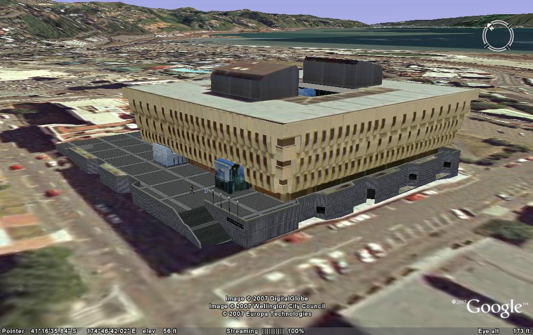
(Click on Image to Enlarge)
Link to this image: http://farm2.static.flickr.com/1010/971357387_6f747e9bc0.jpg
Link to large image: http://farm2.static.flickr.com/1010/971357387_fb76db9f49_o.jpg
Background
Google Earth is a very popular downloadable program for users, that allows one to 'dive in' and navigate the earth as seen from the air. Originally, this would have started out at as a GIS (Geographical Information System) that was mapping satellite photos on to the globe, but a rapid pace of innovation has introduced a lot of extra possibilites. Basically, if you can place it on a map, then it should be placed on this application. A very popular such feature layer is 3D buildings where if you navigate to any place on Google Earth, you can actually see 3D realistic models of buildings standing in their positions. The first such models were built by Google, but since has been opened up to accept user built contributions. Google released a very user-friendly application called Google Sketchup to build such models, and an online repository called 3D Warehouse to store the contributions. Google then assesses these for their suitability for inclusion.
Video of the Model
| URL: | |
| Embed: |
Current status (and how to see it in Google Earth)
Right now this model has been submitted to Google's 3D warehouse. You can search for it by going to the 3D Warehouse site and searching for "National Library" or more specifically "National Library of New Zealand". If you are using Google Earth, please note that the model will not turn up by default in Google's 3D building layer until it goes through Google's approval process, but you can still see it by following the instructions here to get the Google 3D warehouse network link.
I've been doing this project in my 'spare time' at home. Now that I've finished, my wife will finally be happy to get more of my time. Not easy being married to a techie sometimes.
Also ..
just in time for the Library building's 20th Anniversary of completion (5 August 2007)!
Relevant Links
- Official Page on Google 3D Warehouse
- National Library of New Zealand Home Page
- Presentation at BarCamp, Scio-sphere post
- Where to get Google Earth
- How to view Google's 3D building layer
- How to view contributed 3D building content
Apr 16, 2007
Google Earth - New Zealand Tourism Layer
Google Earth - the wonderful service that brought Geographic Information Systems (GIS) technology to the common user level - is now focusing a bit on New Zealand. It helps that Dr Craig Nevill-Manning, Google’s Head of Engineering in New York, is a New Zealander. Tourism New Zealand has tied up with Google Earth to create a specialized information layer on the service.

(Image Courtesy Tourism New Zealand)
For those of you that haven't seen this service yet, Google Earth presents a 3-D interface displaying the Earth's globe, which the user can move in any direction desired. Users can zoom down from space to the street level. One can choose to see the default photographic representation using satellite photo's, or choose a map, and even the contours of terrain. Essentially, the software maps images, features and properties to each longitude and latitude coordinates on the earth model. By selecting different check boxes (representing "layers") you can choose what information is to be displayed on the model - click "Roads" and you will be shown all the road names, click "Accommodation" and you will be shown all the hotel locations etc. Now the new plan is to create a check box that shows detailed authoritative information about New Zealand Tourist locations.

(Image Courtesy Tourism New Zealand)
More news here.
(Image Courtesy Tourism New Zealand)
For those of you that haven't seen this service yet, Google Earth presents a 3-D interface displaying the Earth's globe, which the user can move in any direction desired. Users can zoom down from space to the street level. One can choose to see the default photographic representation using satellite photo's, or choose a map, and even the contours of terrain. Essentially, the software maps images, features and properties to each longitude and latitude coordinates on the earth model. By selecting different check boxes (representing "layers") you can choose what information is to be displayed on the model - click "Roads" and you will be shown all the road names, click "Accommodation" and you will be shown all the hotel locations etc. Now the new plan is to create a check box that shows detailed authoritative information about New Zealand Tourist locations.
(Image Courtesy Tourism New Zealand)
More news here.
Nov 15, 2006
The end of Bangalore
What I was afraid of has finally happened. As part of a patriotic and anti-colonial posturing by the oh-so humble Indian politicians, another city (my old city) has lost its identity. Bangalore has been renamed Bengaluroo. Hmm ... doesn't that sound like the capital of West Bengal?

Bangalore was a name which I loved because it packed a phonetic bang. "Bang-a-lore" I would sing riding around on my trusty motorcycle. When I first arrived in Bangalore, the head of the state goverment was Chief Minister Bangarappa (Bang-a-rapper?). I got my college degree from 'Bangalore University' a name that's known internationally. Believe it or not, Bangalore is an globally recognized (pronounce-able) brand associated with the information technology revolution of India. Due to its loss, the city will take a hit.


It's even funny to know what Bengaluroo may actually mean. There's a popular story that a king from the Hoysala dynasty, while on a hunting expedition, stopped for a meal break and was fed boiled beans by a kindly old lady, and thus he named the old hamlet after that dish - benda kala ooru (in Kannada), the village of boiled beans. However some historians seek to console us that it's not true and that the name actually derives from some specimen of flora.
Indian cartographers have been tearing out their hair vigorously for the past decade or so. Trivandrum became Thiruvananthapuram (even Indians have problems saying that out loud). Bombay (now, did't that sound explosive) became an uninspiring Mumbai. Madras became Chennai (which sounds like another food item). Calcutta became Kolkata (in Hindi that would sound like 'I bit [something] yesterday'). And I haven't even started discussing individual street names yet.
"But it's all the Britisher's fault", protests the Indian politician, "because they couldn't pronounce the Indian dialect, they twisted it into a English sounding word". Granted, but that does not mean that you are doing anyone favours by renaming these cities 40 years after Independence. When the true generation of Indian freedom fighter did not have any problem with these names, why do you?
These names have become identities or brands in their own right, with long histories. A Bombay or Madras does not get located in Britain because of its name. There are no other places in the world with theses names. These names also belonged to India, in fact the India of your fathers and grandfathers. Bangalore had been named thus since 1537.
The politician thinks he or she can go down in history as the person who got the city's name changed. Let me tell you - history doesn't care. In another 100 years your contributions will be judged on other criteria. And what would happen if other politicians got the same idea? Even worse, what would happen if the latest pundit, numerologist, psychic or guru-ji decided that the current name is 'cursed with bad luck'? Well, we'll go skipping along singing another name-changing tune.
See also article in the Economist
Bangalore was a name which I loved because it packed a phonetic bang. "Bang-a-lore" I would sing riding around on my trusty motorcycle. When I first arrived in Bangalore, the head of the state goverment was Chief Minister Bangarappa (Bang-a-rapper?). I got my college degree from 'Bangalore University' a name that's known internationally. Believe it or not, Bangalore is an globally recognized (pronounce-able) brand associated with the information technology revolution of India. Due to its loss, the city will take a hit.
It's even funny to know what Bengaluroo may actually mean. There's a popular story that a king from the Hoysala dynasty, while on a hunting expedition, stopped for a meal break and was fed boiled beans by a kindly old lady, and thus he named the old hamlet after that dish - benda kala ooru (in Kannada), the village of boiled beans. However some historians seek to console us that it's not true and that the name actually derives from some specimen of flora.
Indian cartographers have been tearing out their hair vigorously for the past decade or so. Trivandrum became Thiruvananthapuram (even Indians have problems saying that out loud). Bombay (now, did't that sound explosive) became an uninspiring Mumbai. Madras became Chennai (which sounds like another food item). Calcutta became Kolkata (in Hindi that would sound like 'I bit [something] yesterday'). And I haven't even started discussing individual street names yet.
"But it's all the Britisher's fault", protests the Indian politician, "because they couldn't pronounce the Indian dialect, they twisted it into a English sounding word". Granted, but that does not mean that you are doing anyone favours by renaming these cities 40 years after Independence. When the true generation of Indian freedom fighter did not have any problem with these names, why do you?
These names have become identities or brands in their own right, with long histories. A Bombay or Madras does not get located in Britain because of its name. There are no other places in the world with theses names. These names also belonged to India, in fact the India of your fathers and grandfathers. Bangalore had been named thus since 1537.
The politician thinks he or she can go down in history as the person who got the city's name changed. Let me tell you - history doesn't care. In another 100 years your contributions will be judged on other criteria. And what would happen if other politicians got the same idea? Even worse, what would happen if the latest pundit, numerologist, psychic or guru-ji decided that the current name is 'cursed with bad luck'? Well, we'll go skipping along singing another name-changing tune.
See also article in the Economist
Subscribe to:
Posts (Atom)