Google have done an impressive job of 3D modelling the venues for the Football World Cup 2010 in their Google Earth application. Along with the stadiums, one can also get a good idea of the geography of the surrounding cities and scenery. The following video exhibits this:
Showing posts with label virtual worlds. Show all posts
Showing posts with label virtual worlds. Show all posts
Jun 9, 2010


Jul 31, 2007
National Library 3D Building Model for Google Earth
I'm submitting this model to Google Earth today.
Google Sketchup Model

Link to this image: http://farm2.static.flickr.com/1176/962260016_9c348e09e3_o.jpg
Google Earth view

(Click on Image to Enlarge)
Link to this image: http://farm2.static.flickr.com/1010/971357387_6f747e9bc0.jpg
Link to large image: http://farm2.static.flickr.com/1010/971357387_fb76db9f49_o.jpg
Background
Google Earth is a very popular downloadable program for users, that allows one to 'dive in' and navigate the earth as seen from the air. Originally, this would have started out at as a GIS (Geographical Information System) that was mapping satellite photos on to the globe, but a rapid pace of innovation has introduced a lot of extra possibilites. Basically, if you can place it on a map, then it should be placed on this application. A very popular such feature layer is 3D buildings where if you navigate to any place on Google Earth, you can actually see 3D realistic models of buildings standing in their positions. The first such models were built by Google, but since has been opened up to accept user built contributions. Google released a very user-friendly application called Google Sketchup to build such models, and an online repository called 3D Warehouse to store the contributions. Google then assesses these for their suitability for inclusion.
Video of the Model
Current status (and how to see it in Google Earth)
Right now this model has been submitted to Google's 3D warehouse. You can search for it by going to the 3D Warehouse site and searching for "National Library" or more specifically "National Library of New Zealand". If you are using Google Earth, please note that the model will not turn up by default in Google's 3D building layer until it goes through Google's approval process, but you can still see it by following the instructions here to get the Google 3D warehouse network link.
I've been doing this project in my 'spare time' at home. Now that I've finished, my wife will finally be happy to get more of my time. Not easy being married to a techie sometimes.
Also ..
just in time for the Library building's 20th Anniversary of completion (5 August 2007)!

Relevant Links
Google Sketchup Model
Link to this image: http://farm2.static.flickr.com/1176/962260016_9c348e09e3_o.jpg
Google Earth view
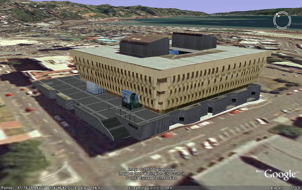
(Click on Image to Enlarge)
Link to this image: http://farm2.static.flickr.com/1010/971357387_6f747e9bc0.jpg
Link to large image: http://farm2.static.flickr.com/1010/971357387_fb76db9f49_o.jpg
Background
Google Earth is a very popular downloadable program for users, that allows one to 'dive in' and navigate the earth as seen from the air. Originally, this would have started out at as a GIS (Geographical Information System) that was mapping satellite photos on to the globe, but a rapid pace of innovation has introduced a lot of extra possibilites. Basically, if you can place it on a map, then it should be placed on this application. A very popular such feature layer is 3D buildings where if you navigate to any place on Google Earth, you can actually see 3D realistic models of buildings standing in their positions. The first such models were built by Google, but since has been opened up to accept user built contributions. Google released a very user-friendly application called Google Sketchup to build such models, and an online repository called 3D Warehouse to store the contributions. Google then assesses these for their suitability for inclusion.
Video of the Model
| URL: | |
| Embed: |
Current status (and how to see it in Google Earth)
Right now this model has been submitted to Google's 3D warehouse. You can search for it by going to the 3D Warehouse site and searching for "National Library" or more specifically "National Library of New Zealand". If you are using Google Earth, please note that the model will not turn up by default in Google's 3D building layer until it goes through Google's approval process, but you can still see it by following the instructions here to get the Google 3D warehouse network link.
I've been doing this project in my 'spare time' at home. Now that I've finished, my wife will finally be happy to get more of my time. Not easy being married to a techie sometimes.
Also ..
just in time for the Library building's 20th Anniversary of completion (5 August 2007)!
Relevant Links
- Official Page on Google 3D Warehouse
- National Library of New Zealand Home Page
- Presentation at BarCamp, Scio-sphere post
- Where to get Google Earth
- How to view Google's 3D building layer
- How to view contributed 3D building content
Jun 25, 2007
From Microsoft Labs ... Seadragon and Photosynth
Webstock Mini-June
We were given a brief glimpse of this technology at Webstock Mini-June conference held here in Wellington last week. The presenter was Leigh Blackall, he showed us some features of Second Life virtual world. Proceeding on that topic he also gave us a brief glimpse of Photosynth. Curiosity drove me to the source.
TED
With the competition in internet innovation hotting up these days a lot of brilliant ideas are finding voice. An exciting development to come out of Microsoft Labs was demonstrated at the TED (Technology, Entertainment, Design) talks held every year in California, United States.
Seadragon
This was the first of the two technologies presented. Using the new Windows Media Photo Format, examples were shown of collages of photographs, that can be zoomed endlessly down to the tiniest level, smoothly and effortlessly. At one stage the software architect Blaise Aguera Y Arcas, mentioned that they were using 300 MegaPixel images. To put that in perspective, most images we get from digital cameras are only around 3 to 5 MegaPixels, and these are capable of being printed in large poster format without distortion. To facilitate this kind of technology I would normally assume that the software that can manipulate objects of this size would be very sophisticated and complex, requiring machines at super-computer level including giant memory stores connected to a very large bandwidth network. Yet, this project, which is under incubation at Microsoft Live Labs promises:

PhotoSynth
This other project from Microsoft Live Labs allows one to see the photos in a context of 3D virtual world representation of the place where the photograph was taken. The model seems to map the position of the camera, the position of the photographed subject, and the photograph itself. Now, integrated with countless other photographs in the same area. What you effectively build up is a 3D world showing the view from any point in any direction using available photographic detail of the area.
Some latest digital cameras that come with built in Global Positioning System (GPS) sensors could, theoretically, encode the photograph itself with the data (or metadata) of where it was taken. To get the effective 3D coordinates, the metadata should also include the height in terms of 'above sea-level' of the photographer. However, Photosynth works from the other end - it takes your photographs, analyzes them, and working from familiar features in the photo - such as the architectural lines of a known building, determines the position and angle of the camera. Thus, the onus is lifted from the user to provide the location metadata for the photo.
There are further benefits envisaged to this technology such as Smart Photos - the idea of taking a photo of some item with your cellphone-camera, and sending it to a service that determines what's in the picture and sending you back information about the subject. Great for tourists!
You can install and try out the software, but note the system requirements before you begin.
One particular word said by the presenter is going to stick around in my mind - metaverse. It seems to be a reference to a universe built by amalgamation of all kinds of related objects, facilitated by the metadata of those objects.
The TED Presentation
We were given a brief glimpse of this technology at Webstock Mini-June conference held here in Wellington last week. The presenter was Leigh Blackall, he showed us some features of Second Life virtual world. Proceeding on that topic he also gave us a brief glimpse of Photosynth. Curiosity drove me to the source.
TED
With the competition in internet innovation hotting up these days a lot of brilliant ideas are finding voice. An exciting development to come out of Microsoft Labs was demonstrated at the TED (Technology, Entertainment, Design) talks held every year in California, United States.
Seadragon
This was the first of the two technologies presented. Using the new Windows Media Photo Format, examples were shown of collages of photographs, that can be zoomed endlessly down to the tiniest level, smoothly and effortlessly. At one stage the software architect Blaise Aguera Y Arcas, mentioned that they were using 300 MegaPixel images. To put that in perspective, most images we get from digital cameras are only around 3 to 5 MegaPixels, and these are capable of being printed in large poster format without distortion. To facilitate this kind of technology I would normally assume that the software that can manipulate objects of this size would be very sophisticated and complex, requiring machines at super-computer level including giant memory stores connected to a very large bandwidth network. Yet, this project, which is under incubation at Microsoft Live Labs promises:
- Speed of navigation is independent of the size or number of objects.
- Performance depends only on the ratio of bandwidth to pixels on the screen.
- Transitions are smooth as butter.
- Scaling is near perfect and rapid for screens of any resolution.
PhotoSynth
This other project from Microsoft Live Labs allows one to see the photos in a context of 3D virtual world representation of the place where the photograph was taken. The model seems to map the position of the camera, the position of the photographed subject, and the photograph itself. Now, integrated with countless other photographs in the same area. What you effectively build up is a 3D world showing the view from any point in any direction using available photographic detail of the area.
Some latest digital cameras that come with built in Global Positioning System (GPS) sensors could, theoretically, encode the photograph itself with the data (or metadata) of where it was taken. To get the effective 3D coordinates, the metadata should also include the height in terms of 'above sea-level' of the photographer. However, Photosynth works from the other end - it takes your photographs, analyzes them, and working from familiar features in the photo - such as the architectural lines of a known building, determines the position and angle of the camera. Thus, the onus is lifted from the user to provide the location metadata for the photo.
There are further benefits envisaged to this technology such as Smart Photos - the idea of taking a photo of some item with your cellphone-camera, and sending it to a service that determines what's in the picture and sending you back information about the subject. Great for tourists!
You can install and try out the software, but note the system requirements before you begin.
One particular word said by the presenter is going to stick around in my mind - metaverse. It seems to be a reference to a universe built by amalgamation of all kinds of related objects, facilitated by the metadata of those objects.
The TED Presentation
Subscribe to:
Posts (Atom)