Google have done an impressive job of 3D modelling the venues for the Football World Cup 2010 in their Google Earth application. Along with the stadiums, one can also get a good idea of the geography of the surrounding cities and scenery. The following video exhibits this:
Showing posts with label google earth. Show all posts
Showing posts with label google earth. Show all posts
Jun 9, 2010


Jul 31, 2007
National Library 3D Building Model for Google Earth
I'm submitting this model to Google Earth today.
Google Sketchup Model

Link to this image: http://farm2.static.flickr.com/1176/962260016_9c348e09e3_o.jpg
Google Earth view

(Click on Image to Enlarge)
Link to this image: http://farm2.static.flickr.com/1010/971357387_6f747e9bc0.jpg
Link to large image: http://farm2.static.flickr.com/1010/971357387_fb76db9f49_o.jpg
Background
Google Earth is a very popular downloadable program for users, that allows one to 'dive in' and navigate the earth as seen from the air. Originally, this would have started out at as a GIS (Geographical Information System) that was mapping satellite photos on to the globe, but a rapid pace of innovation has introduced a lot of extra possibilites. Basically, if you can place it on a map, then it should be placed on this application. A very popular such feature layer is 3D buildings where if you navigate to any place on Google Earth, you can actually see 3D realistic models of buildings standing in their positions. The first such models were built by Google, but since has been opened up to accept user built contributions. Google released a very user-friendly application called Google Sketchup to build such models, and an online repository called 3D Warehouse to store the contributions. Google then assesses these for their suitability for inclusion.
Video of the Model
Current status (and how to see it in Google Earth)
Right now this model has been submitted to Google's 3D warehouse. You can search for it by going to the 3D Warehouse site and searching for "National Library" or more specifically "National Library of New Zealand". If you are using Google Earth, please note that the model will not turn up by default in Google's 3D building layer until it goes through Google's approval process, but you can still see it by following the instructions here to get the Google 3D warehouse network link.
I've been doing this project in my 'spare time' at home. Now that I've finished, my wife will finally be happy to get more of my time. Not easy being married to a techie sometimes.
Also ..
just in time for the Library building's 20th Anniversary of completion (5 August 2007)!

Relevant Links
Google Sketchup Model
Link to this image: http://farm2.static.flickr.com/1176/962260016_9c348e09e3_o.jpg
Google Earth view
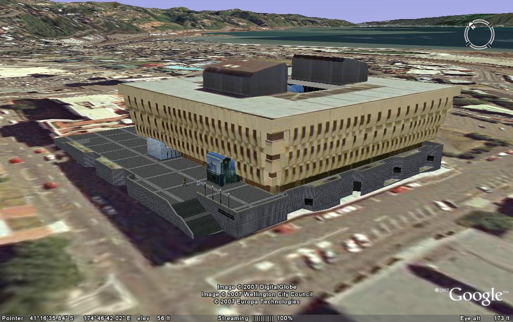
(Click on Image to Enlarge)
Link to this image: http://farm2.static.flickr.com/1010/971357387_6f747e9bc0.jpg
Link to large image: http://farm2.static.flickr.com/1010/971357387_fb76db9f49_o.jpg
Background
Google Earth is a very popular downloadable program for users, that allows one to 'dive in' and navigate the earth as seen from the air. Originally, this would have started out at as a GIS (Geographical Information System) that was mapping satellite photos on to the globe, but a rapid pace of innovation has introduced a lot of extra possibilites. Basically, if you can place it on a map, then it should be placed on this application. A very popular such feature layer is 3D buildings where if you navigate to any place on Google Earth, you can actually see 3D realistic models of buildings standing in their positions. The first such models were built by Google, but since has been opened up to accept user built contributions. Google released a very user-friendly application called Google Sketchup to build such models, and an online repository called 3D Warehouse to store the contributions. Google then assesses these for their suitability for inclusion.
Video of the Model
| URL: | |
| Embed: |
Current status (and how to see it in Google Earth)
Right now this model has been submitted to Google's 3D warehouse. You can search for it by going to the 3D Warehouse site and searching for "National Library" or more specifically "National Library of New Zealand". If you are using Google Earth, please note that the model will not turn up by default in Google's 3D building layer until it goes through Google's approval process, but you can still see it by following the instructions here to get the Google 3D warehouse network link.
I've been doing this project in my 'spare time' at home. Now that I've finished, my wife will finally be happy to get more of my time. Not easy being married to a techie sometimes.
Also ..
just in time for the Library building's 20th Anniversary of completion (5 August 2007)!
Relevant Links
- Official Page on Google 3D Warehouse
- National Library of New Zealand Home Page
- Presentation at BarCamp, Scio-sphere post
- Where to get Google Earth
- How to view Google's 3D building layer
- How to view contributed 3D building content
Jul 18, 2007
BarCamp
We had BarCamp at work.
BarCamp, you say? Wikipedia begins to define it as an 'unconference', but that was where the similarity ended. Normally, a BarCamp is about Information Technology professionals getting together and sharing their knowledge in an open communicative environment. When it comes to geeks (mostly unmarried) and communications it means - Laptops, Wi-Fi, Blogs, Wikis, Coding, Sleeping Bags and so on. However in our building we have more librarians then techies.
There was basically an open schedule board, where participants could sign up to give a presentation, or be a moderator. In this case, no topic was off-topic. The schedule was to be finalised, hardly 5 minute before the event. It was planned that each session, the presenter had a few minutes to showcase his/her idea and then the audience joins into a discussion. Of course, depending on the topic there were variations.
I moderated a couple of very significant sessions, presented by a fellow techie colleague related to hotdesking with terminals and remote access to office applications. There was a lot of interest from the audience/participants in what's-in-it-for-us fashion. In my turn, I presented a unprepared session (in the spirit of the un-conference) on Google Earth and our interest there (picture below). I gave a demo in 3-dimensional modeling in Google Sketchup, attempting to show how easy it is. I also presented a few ready-made models from Google's 3D Warehouse such as the Taj Mahal and Eiffel Tower. I was taken aback to notice that our CEO was also in the audience - she asked some very good questions related to importing of CAD drawings into Sketchup software. Everybody was interested in the technology and wanted to know more on how to get into this and what was required to contribute.

Overall, the event generated a lot of involvement, buzz and energy - above normal levels. I enjoyed playing the roles of organising team member, moderator and presenter.There's a plan to follow up with a similar and longer event in a month or so.
BarCamp, you say? Wikipedia begins to define it as an 'unconference', but that was where the similarity ended. Normally, a BarCamp is about Information Technology professionals getting together and sharing their knowledge in an open communicative environment. When it comes to geeks (mostly unmarried) and communications it means - Laptops, Wi-Fi, Blogs, Wikis, Coding, Sleeping Bags and so on. However in our building we have more librarians then techies.
There was basically an open schedule board, where participants could sign up to give a presentation, or be a moderator. In this case, no topic was off-topic. The schedule was to be finalised, hardly 5 minute before the event. It was planned that each session, the presenter had a few minutes to showcase his/her idea and then the audience joins into a discussion. Of course, depending on the topic there were variations.
I moderated a couple of very significant sessions, presented by a fellow techie colleague related to hotdesking with terminals and remote access to office applications. There was a lot of interest from the audience/participants in what's-in-it-for-us fashion. In my turn, I presented a unprepared session (in the spirit of the un-conference) on Google Earth and our interest there (picture below). I gave a demo in 3-dimensional modeling in Google Sketchup, attempting to show how easy it is. I also presented a few ready-made models from Google's 3D Warehouse such as the Taj Mahal and Eiffel Tower. I was taken aback to notice that our CEO was also in the audience - she asked some very good questions related to importing of CAD drawings into Sketchup software. Everybody was interested in the technology and wanted to know more on how to get into this and what was required to contribute.
Overall, the event generated a lot of involvement, buzz and energy - above normal levels. I enjoyed playing the roles of organising team member, moderator and presenter.There's a plan to follow up with a similar and longer event in a month or so.
Apr 16, 2007
Google Earth - New Zealand Tourism Layer
Google Earth - the wonderful service that brought Geographic Information Systems (GIS) technology to the common user level - is now focusing a bit on New Zealand. It helps that Dr Craig Nevill-Manning, Google’s Head of Engineering in New York, is a New Zealander. Tourism New Zealand has tied up with Google Earth to create a specialized information layer on the service.

(Image Courtesy Tourism New Zealand)
For those of you that haven't seen this service yet, Google Earth presents a 3-D interface displaying the Earth's globe, which the user can move in any direction desired. Users can zoom down from space to the street level. One can choose to see the default photographic representation using satellite photo's, or choose a map, and even the contours of terrain. Essentially, the software maps images, features and properties to each longitude and latitude coordinates on the earth model. By selecting different check boxes (representing "layers") you can choose what information is to be displayed on the model - click "Roads" and you will be shown all the road names, click "Accommodation" and you will be shown all the hotel locations etc. Now the new plan is to create a check box that shows detailed authoritative information about New Zealand Tourist locations.

(Image Courtesy Tourism New Zealand)
More news here.
(Image Courtesy Tourism New Zealand)
For those of you that haven't seen this service yet, Google Earth presents a 3-D interface displaying the Earth's globe, which the user can move in any direction desired. Users can zoom down from space to the street level. One can choose to see the default photographic representation using satellite photo's, or choose a map, and even the contours of terrain. Essentially, the software maps images, features and properties to each longitude and latitude coordinates on the earth model. By selecting different check boxes (representing "layers") you can choose what information is to be displayed on the model - click "Roads" and you will be shown all the road names, click "Accommodation" and you will be shown all the hotel locations etc. Now the new plan is to create a check box that shows detailed authoritative information about New Zealand Tourist locations.
(Image Courtesy Tourism New Zealand)
More news here.
Subscribe to:
Posts (Atom)