Showing posts with label geography. Show all posts

Nov 8, 2015

City to Megalopolis to Ecumenopolis - as far as the eye can see

Aerial views of New Delhi, India, which has a population density of 30,000 people per square mile, show the sheer number of humans living on top of each other. (Business Insider)

Travelling by train from Delhi to Punjab and back, at least once a year, is something I have done since I was born. The distance between my mother’s family and my father’s was covered by the trusty North-Western Indian Railway, but the journey has changed each year that I have made it. Twenty years ago, we could drink the water straight from the many public taps, eat the delicious food hand-made from the various stalls by jolly gents, served in small bowls made from dried leaves. Sip tea in earthern clay cups which one could later smash, almost ceremonially, on the tracks without impacting the environment. There was a substantial feeling of space, of cooler fresher air, cleaner sunshine. The population of India then was a bit over 780,000.

Now it is approaching double that figure - at the time of writing about 1.3 billion. The population graph is an unsustainable exponential, with unthinkable consequences. The train journey of my childhood is very different now, impacts of crowding, resource pressure, commercialisation and inequality very clear to behold. The water from the public taps is an unknown risk, the food is made from untrustworthy sources, made by unreliable and uncaring hands, belonging to people who have been standing in the blistering heat all day, in a wind that blows hot, mixed with fumes of diesel and rot. The sunshine is a brownish yellow, and at night the stars are veiled. 

The main difference though is the disappearing countryside. Twenty years ago, the view from the iron-barred open train windows was of a rolling countryside - farmlands upon farmlands, a plethora of ponds, some with cattle floating merrily, the small towns flashed by quickly. Now the view from the tracks of the whole journey, from one major city, Delhi, population:22 million to another Ludhiana, population:1.6 million barely seems to touch upon green at all. The rail tracks border towns are expanding, infused with new boisterous economy, factories everywhere, large residential colonies for the new ‘aspirational classes’. The quiet farmers seem lost in all this, out of place. I had contemplated the urban emergence being akin to a monster, being fed by rail and highways, growing remarkably, with disturbing speed. It’s not long now, before the entire journey of 320km (200miles) would be through a continuous urban corridor.

This phenomena occurring throughout the ‘tiger’ economies of Asia is being referred to as the emergence of ‘The Great Asia Megacity’. In an article on ANZ’s Bluenotes on the ‘The Hyper Urbanisation of Asia’:

What if your urban hipster lifestyle was not in a city of 5 million people? Or even 10 million people? How would a hipster define "urban" in a mega-urban-agglomeration of nearly 3 billion people stretching nearly 12,000 kilometres from its northern to southern suburbs? Would you want to be right in the centre of that urban sprawl or would outer suburban fringe dwelling be more suited for you? 
Welcome to the future cities of Asia! Indeed, we may be misleading you already. A process of hyper-urbanisation is already underway across Asia. If that development continues at its current pace and depth it would inevitably lead to the entire urbanised population of Asia coalescing into one contiguous mega-urban-region that will hug the Pacific rim from Beijing in the North to Jakarta in the South. It will be the greatest city mankind has ever known. - The Hyper-Urbanisation of Asia Part 1: Asiaopolis

The above article series explores this phenomena from a economic opportunity point of view, but one can’t help but be dismayed about what this will mean in terms of planetary impact.  It has to be realised that this is not just a study in abstract, but the today and tomorrow of the very biosphere that surrounds us. The articles also discuss the following terms:

Megalopolis:  a chain of roughly adjacent metropolitan areas which eventually fuse into one contiguous urban area (from article)

Eperapolis: a city that occupies a continent (from article)

Ecumenopolis:  a city made of the whole world

Now, where have I seen this before? Ah yes, in the world of Science-Fiction, in the very centre of Isaac Asimov’s Foundation series (1942-) setting of a galaxy-wide human empire lies a capital city of Trantor. (The concept was also copied in Star Wars universe’s capital city-planet of Coruscant) This city, that defined the term Ecumenopolis, is actually a whole planet - borderless, continuous, without respite, all in metal, closed to the sky and closed to the ground. In the author’s own words .. 

“TRANTOR— . . . At the beginning of the thirteenth millennium, this tendency reached its climax. As the center of the Imperial Government for unbroken hundreds of generations and located, as it was, toward the central regions of the Galaxy among the most densely populated and industrially advanced worlds of the system, it could scarcely help being the densest and richest clot of humanity the Race had ever seen. 
Its urbanization, progressing steadily, had finally reached the ultimate. All the land surface of Trantor, 75,000,000 square miles in extent, was a single city. The population, at its height, was well in excess of forty billions. This enormous population was devoted almost entirely to the administrative necessities of Empire, and found themselves all too few for the complications of the task. (It is to be remembered that the impossibility of proper administration of the Galactic Empire under the uninspired leadership of the later Emperors was a considerable factor in the Fall.) Daily, fleets of ships in the tens of thousands brought the produce of twenty agricultural worlds to the dinner tables of Trantor. . . .” 
Excerpt From: Isaac Asimov. “Foundation.”
We are not yet the centre of the galactic-empire. We haven’t even set foot beyond the moon. There is nowhere else to go, to source our dinner tables from, so what we do with this planet will echo back at our well being and quality of life. Right now the calculations of human governance do not factor in the environment, so things are out balance. From current standpoint the scales are going to tilt till some non-anthropocentric agency comes to righten things, when and which agency are questions to the future.

Following maps show the impact on the land corridor I referred to in the first few paragraphs. The data still does not take into account the last 5 years of further exponential growth. You can infer if the development is positive or otherwise.

Map from Earth Institute, Columbia University

On that train journey, we don’t buy open food from the stalls anymore, or drink from the public taps. The more affluent, we seal ourselves in air-conditioned train bogeys with sealed-windows , where the food is served from train-authorised on-board catering, with water out of hermetically sealed plastic bottles. There’s a note on the bottle, to remember to crush before disposing, just in case it is picked up and reused and re-sold in counterfeit. The less-affluent still use the regular resources, they can’t afford the high-priced guaranteed food. They are exposed to all the risks of less controlled products. The half-joke runs that their bodies have higher immunity. The joke on me is that after eating the ‘better-quality’ food I still got sick.

And you..
What about your travels - what and where have you seen change over time? The good changes, the not so good? Feel free to comment.

Feb 25, 2011

So when do India/China catch up?

I've had the opportunity to see Hans Rosling before in conferences, and one can't help but be infected by his sense of enthusiasm at the stories which his powerful interpretation of statistics reveal.

I guess his broadmindedness is partly explained by this stint in India as a student. I didn't know that before.

There is a new field or term emerging called data visualisation. The experts describe 'a sea of data' which is now available globally and accessible anywhere online. The problem is how to interpret it to reveal its hidden narrative. To find the simple story within the data/information overload. Rosling has been doing that since a long time before.

Thanks to the following presentation, 37 years from is now a milestone all of Asia would have its eye on. Striding along the stage with an "environmentally-friendly" presentation pointer, Rosling looks a bit like a modern day Gandhi, just carrying a bigger stick. He understands and sympathises with the emotional touch points of Indian audience and navigates them well. The prediction graphs and statistics are not going to progress on their own, we will have to live each day to that future date and contribute to the trajectory.

In case you don't want to see the whole video, Rosling answers the question at about 14 minutes from the start...


*        *        *

Jun 9, 2010

FIFA 2010 Stadiums in Google Earth

Google have done an impressive job of 3D modelling the venues for the Football World Cup 2010 in their Google Earth application. Along with the stadiums, one can also get a good idea of the geography of the surrounding cities and scenery. The following video exhibits this:


Feb 5, 2010

Ancient Language becomes Extinct

Hurtling along at great speed into a globally technology-connected future, conditions are set for localised cultures, that depended on their isolation, to evolve out of existence. Now BBC passes on the message from Professor Anvita Abbi of Jawaharlal Nehru University, that Bo, one of humanity's oldest languages has vanished into history, with the demise of it's last speaker. This language used to exist in the Andaman and Nicobar Islands of India which, as the map below (from andamanese.net) shows, has undergone drastic demographic change.


I remember a documentary my family saw in the 1980s on these islands. The documentary-maker-explorers described the tribals as easily provoked and very dangerous. Standing on the ships off the shore they would wave food parcels and gifts to the nervous bewildered tribals, who kept their poison-tipped arrows poised. Not very different from the meeting of cultures portrayal in the latest Avatar movie.

Times will change and cultures will transform, but in an age where audio and video recording of every expression is possible, the heritage can be preserved to some extent. Prof. Abbi has done a lot of work in this direction recording the exact phonetics as well.
Boa Sr, who died last week aged around 85, was the last speaker of ‘Bo’, one of the ten Great Andamanese languages. The Bo are thought to have lived in the Andaman Islands for as much as 65,000 years, making them the descendants of one of the oldest human cultures on Earth.

Boa Sr was the oldest of the Great Andamanese, who now number just 52. Originally ten distinct tribes, the Great Andamanese were 5,000 strong when the British colonized the Andaman Islands in 1858. Most were killed or died of diseases brought by the colonizers.

And, sadly this will not be last language to disappear in the region.
It is generally believed that all Andamanese languages might be the last representative of those languages whose history goes back to pre-Neolithic times in Southeast Asia and possibly the first settlement of the region by modern humans. These isolated Andamanese languages that are spoken by the descendents of the aboriginal population of Southeast Asia are, at present, ‘very critical’ stage.

A useful description of how to identify languages on the path of fading out is in a paper by Prof. Abbi and colleagues:
Moribund languages are characterized by lack of will to learn and teach the heritage language. The language does not get transferred from the older to the younger generation. Another important feature of the moribund languages is loss of registers and reduced domains of use. In the restricted domains that the language is used show traces of earlier varieties in lexical items and grammatical structures once spoken. The loss of various registers also results in the lack of total mutual intelligibility even among the speakers who have retained the language.
- Where Have all the Speakers Gone? A Sociolinguistic Study of the Great Andamanese, by Anvita Abbi, Bidisha Som and Alok Das, Jawaharlal Nehru University, New Delhi. PDF file

Jan 6, 2010

Tallest building on Earth

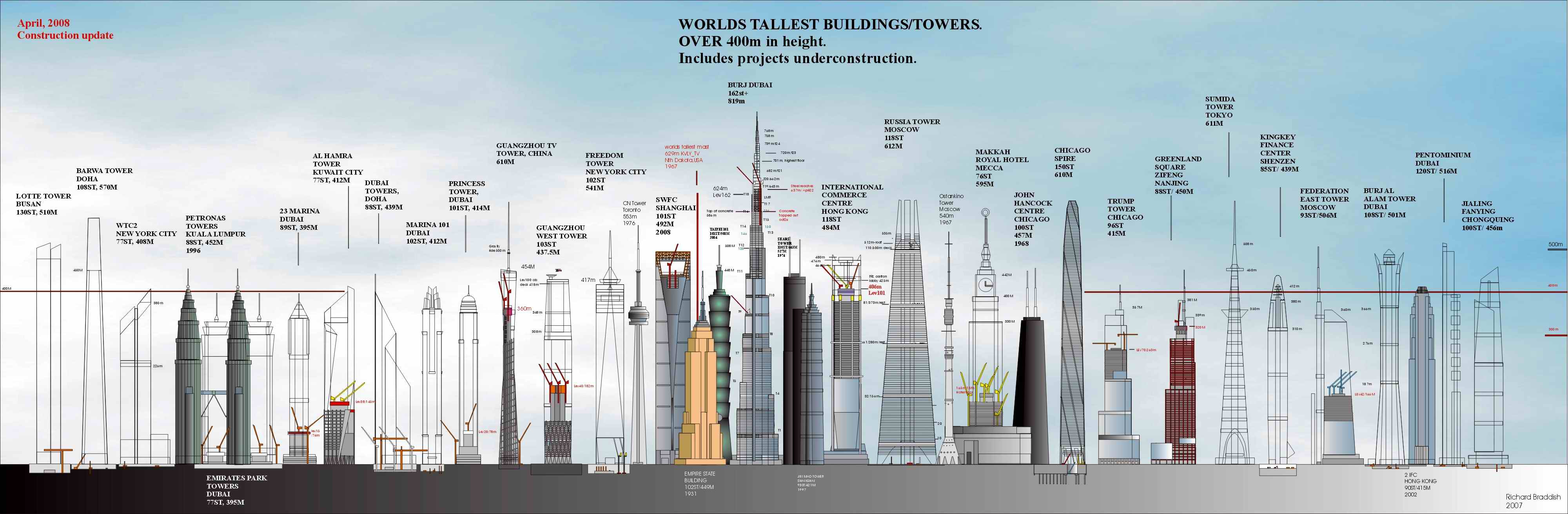
The latest tallest building on Earth, Burj Khalifa (formerly Burj Dubai), was inaugurated in Dubai in a glittering ceremony of fireworks, lights, and musical fountains. The building touches the milestone of 828 meters (or 2,717 feet) with 162 floors. Construction started on 21 September 2004, and has been completed on 4 January 2010. The opening ceremony can be seen here


A comparison with some of the existing tallest man-made structures (not counting projects in planning or construction) produces the diagram below. If you want to consider New Zealand's tallest structure, the Auckland Sky Tower at 328 meters, you can put it at approximately the size of the Eiffel Tower on the diagram. India's highest buliding is currently the Imperial towers in Mumbai at 60 floors and 249 meters.


Having the good fortune to have seen almost all the structures in the diagram(except for the Taipei 101 & CN tower), I look forward to seeing this one.

Here's another detailed diagram comparing world edifices reaching above 400 meters benchmark. The current completed buildings are in full representation, while the in-progress constructions are shown as line drawings.


It's probably unlikely that the Burj Khalifa will remain the highest building with so many newly emerging nations and conglomerates also eyeing that coveted title. Burj's predecessor the Taipei 101 (509 meters) only held the title for 6 years, not allowing the Shanghai World Financial Centre (492 meters) to even get a chance. Previous to that the Petronas Towers, Kuala Lumpur (452 meters) were the highest for 6 years, and the Willis Towers, Chicago (formerly Sears Towers) was the highest for 24 years.

However, it will be difficult to match the longevity of the building that held the title for 3880 years - the Great Pyramid of Khufu (Cheops). Here is an interesting, though very detailed diagram of the tallest buildings of the 'old' world.


Image credits: Wikipedia.org & flickr.com

Aug 9, 2007

दुनिया की सबसे ऊंची सीमा पे संगीत की धारा

EverestConcert

हिंदी में मेरी पहली ब्लोग। ब्लॉगर में अंग्रेजी के अलावा पहली भाषा हिंदी डाली गयी है।

बीबीसी से खबर है के एक संगीत ग्रुप ने एवरेस्ट (या सागरमथा) के करीब बुलंदी पे कांसर्ट पेश किया। पता नही अगर इतनी कम आक्सीजन वाली हवा में जाके इन कलाकारो की धुन भी ना बदल गयी हो।

ये वर्ल्ड रेकॉर्ड तोड़ने और चन्दा इकठ्ठा करने के लिए किया गया। आगे की खबर इस साइट पे है


.

Jul 31, 2007

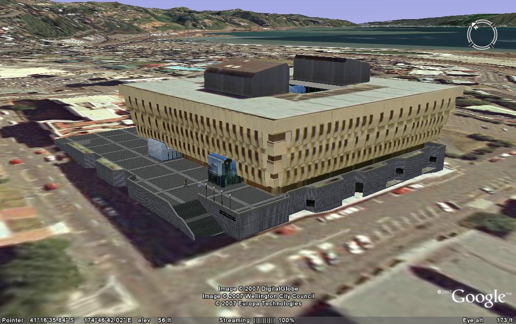
National Library 3D Building Model for Google Earth

I'm submitting this model to Google Earth today.

Google Sketchup Model

National Library of New Zealand, Google Earth Model Image
Link to this image: http://farm2.static.flickr.com/1176/962260016_9c348e09e3_o.jpg

Google Earth view

Google Earth View - Click to Enlarge
(Click on Image to Enlarge)
Link to this image: http://farm2.static.flickr.com/1010/971357387_6f747e9bc0.jpg
Link to large image: http://farm2.static.flickr.com/1010/971357387_fb76db9f49_o.jpg


Background

Google Earth is a very popular downloadable program for users, that allows one to 'dive in' and navigate the earth as seen from the air. Originally, this would have started out at as a GIS (Geographical Information System) that was mapping satellite photos on to the globe, but a rapid pace of innovation has introduced a lot of extra possibilites. Basically, if you can place it on a map, then it should be placed on this application. A very popular such feature layer is 3D buildings where if you navigate to any place on Google Earth, you can actually see 3D realistic models of buildings standing in their positions. The first such models were built by Google, but since has been opened up to accept user built contributions. Google released a very user-friendly application called Google Sketchup to build such models, and an online repository called 3D Warehouse to store the contributions. Google then assesses these for their suitability for inclusion.

Video of the Model


URL:
Embed:

Current status (and how to see it in Google Earth)

Right now this model has been submitted to Google's 3D warehouse. You can search for it by going to the 3D Warehouse site and searching for "National Library" or more specifically "National Library of New Zealand". If you are using Google Earth, please note that the model will not turn up by default in Google's 3D building layer until it goes through Google's approval process, but you can still see it by following the instructions here to get the Google 3D warehouse network link.

I've been doing this project in my 'spare time' at home. Now that I've finished, my wife will finally be happy to get more of my time. Not easy being married to a techie sometimes.

Also ..
just in time for the Library building's 20th Anniversary of completion (5 August 2007)!

National Library of New Zealand Foundation Stone

Relevant Links

Apr 16, 2007

Google Earth - New Zealand Tourism Layer

Google Earth - the wonderful service that brought Geographic Information Systems (GIS) technology to the common user level - is now focusing a bit on New Zealand. It helps that Dr Craig Nevill-Manning, Google’s Head of Engineering in New York, is a New Zealander. Tourism New Zealand has tied up with Google Earth to create a specialized information layer on the service.

Google Earth - New Zealand Tourism Layer
(Image Courtesy Tourism New Zealand)

For those of you that haven't seen this service yet, Google Earth presents a 3-D interface displaying the Earth's globe, which the user can move in any direction desired. Users can zoom down from space to the street level. One can choose to see the default photographic representation using satellite photo's, or choose a map, and even the contours of terrain. Essentially, the software maps images, features and properties to each longitude and latitude coordinates on the earth model. By selecting different check boxes (representing "layers") you can choose what information is to be displayed on the model - click "Roads" and you will be shown all the road names, click "Accommodation" and you will be shown all the hotel locations etc. Now the new plan is to create a check box that shows detailed authoritative information about New Zealand Tourist locations.


(Image Courtesy Tourism New Zealand)

More news here.